Here there be robots: A medieval map of Mars
Although I’m not an astronomer, I love reading about Mars missions and looking through the free data released by NASA. This month I decided to create a map to showcase the wealth of knowledge scientists have accumulated over the past few decades.
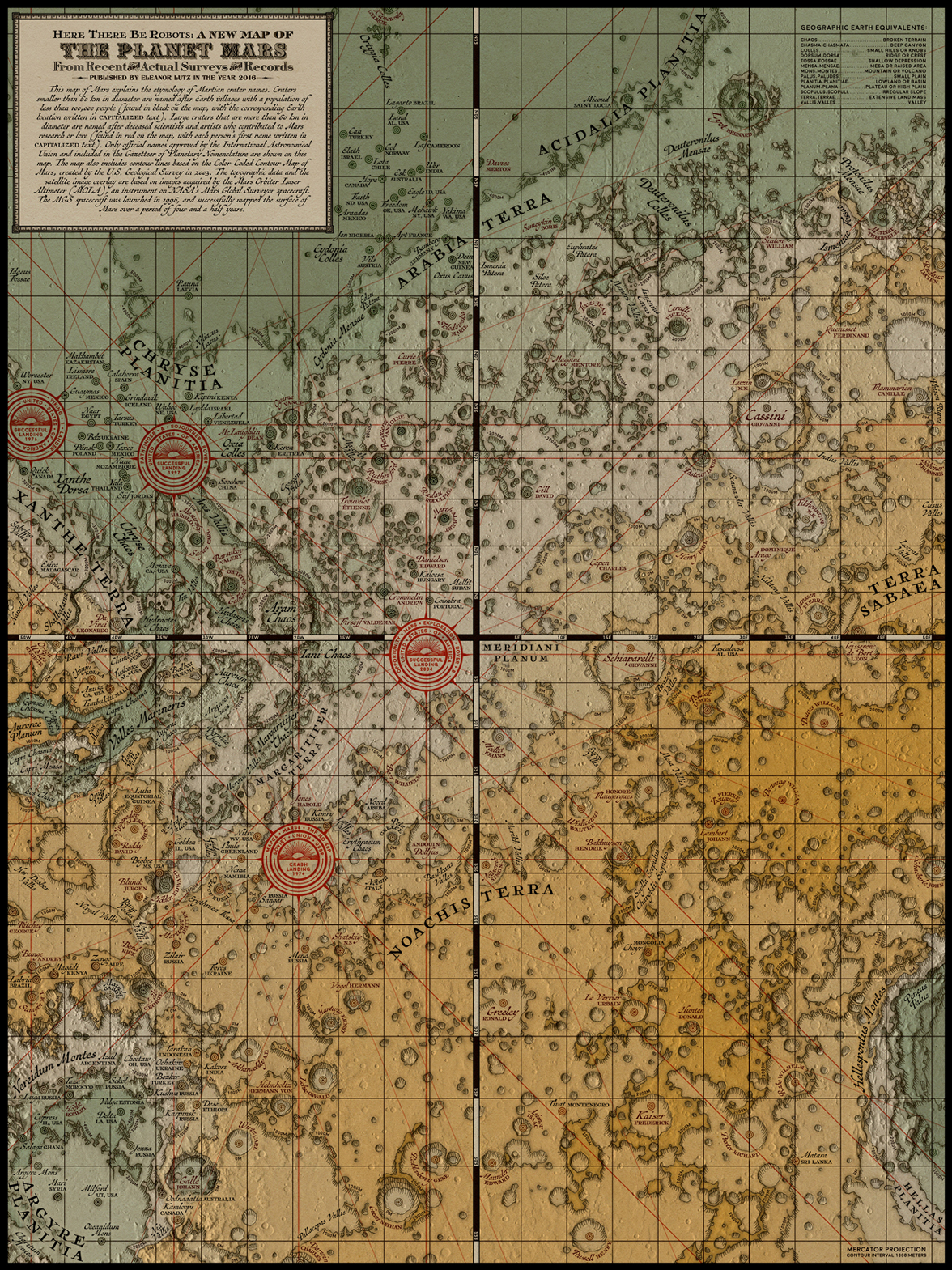
Unlike other planetary maps, this map uses a Victorian style inspired by medieval cartographers. Victorian-style maps are from a time when most of the world remained a mystery, and travelers only knew about nearby lands. Now that people have mapped the entire globe, I think that Mars has taken over our collective imagination as the next mystery to explore. I wanted to use this thematic connection to tie together our history of exploration with our current adventures into unexplored lands.
To make this map I hand-traced topographic data from the USGS Color-Coded Contour Map of Mars to give the map a traditional aesthetic. The hand-traced topographic lines weren’t very exact, so I added an overlay of satellite imagery from the NASA Mars Orbital Laser Altimeter. I also used naming information from the Gazetteer of Planetary Nomenclature and location information from the Mars 1:5 million-scale THEMIS Images.
To add a little something extra, I wanted to share some of the interesting history behind the geographic features on Mars. For example, craters on Mars are named after Earth towns, scientists, or famous artists. In this map I tried to make a strange planet seem familiar by prominently sharing the Earth origins of each crater name.
-
Sources
- Cartography: Color-Coded Contour Map of Mars” USGS Astrogeology Science Center, 2003, “Gazetteer of Planetary Nomenclature” NASA, USGS Astrogeology Science Center, International Astronomical Union, “Mars 1:5 million-scale THEMIS Images” NASA, USGS Astrogeology Science Center, International Astronomical Union
- Fonts used: Moon Bold by Jack Harvatt, Chipperfield & Bailey by Paul Lloyd, Titania by Dieter Steffman, Antiquarian™ and Antiquarian Scribe™ by Brian Willson, and various elements cannibalized from old maps in the NY Public Library's Digital Collection (1, 2, 3).
© This work is shared under a Creative Commons Attribution-NonCommercial-NoDerivatives 4.0 International License.